
We are very fortunate that The English Channel has some of the best wreck diving in the world, due mainly to WW1 and WW2. There are over 50 shipwrecks within 15 miles of Brighton Marina and hundreds more in diveable depths.
If you would like more information on these dive sites and others, detailed descriptions can be found in the book – ‘A DIVER GUIDE – DIVE SUSSEX’ Reference against each entry listed here relate to entries in the book.
Please note: depths, distances, geographic coordinates are all approximate.
Our favourite wreck sites are listed below:
ALAUNIA
Latitude: 50 41.00 N
Longitude: 00 27.20 E
Distance: 22.5nm bearing 109T from BRIGHTON 8.1nm bearing 143T from EASTBOURNE MARINA
Tonnage: 13405
Built: 1913
Sunk: 1916
Depth: 36m
Height: 12m
Dive details: A huge Cunard Liner, sunk in 1916 by a German mine. Superstructure swept and lies on seabed alongside. Well broken up now from amidships and towards stern. but still retains much of its original form. Sits on its port side 45 degrees on a sand and shingle seabed.
Ref: DS 327
ARIEL
Latitude: 50 38.90 N
Longitude: 00 24.80 W
Distance: 15.1nm bearing 230T from BRIGHTON 12.3nm bearing 211T from SHOREHAM
Tonnage: 2220
Built: 1885
Sunk: 1892
Depth: 32m
Height: 2m
Dive details: The SS Ariel is a historic 2,220-tonne British steel cargo steamer built in 1885 that sank in June 1892 following a foggy collision with the steamship Lancashire. It now rests upright on the seabed at a depth of roughly 28 to 30 meters off the West Sussex/Sussex coast. The wreck site is about 95m long. The decks have broken up revealing some inners. It is possible to swim through the central bridge section and engine and boiler rooms. This is a great dive. You can get round the whole ship on one dive.
Ref: DS 161
ASHFORD
Latitude: 50 39.10 N
Longitude: 00 07.70 E
Distance: 12.9nm bearing 136T from BRIGHTON 7.8nm bearing 160T from NEWHAVEN
Tonnage: 1211
Sunk: 1906
Depth: 30m
Height: 6m
Dive details: Deep wreck -The Ashford is a 1882 steamer a few miles off Beachy Head, it was sunk in 1906 after a collision with a German barque. A great dive lots of sealife – crabs, lobsters, congers and fish. Ref: DS 268
BARGE (AMMUNITION)
Latitude: 50 47.30 N
Longitude: 00 07.20 W
Distance: 1.3nm bearing 206T from BRIGHTON 5.2nm bearing 114T from SHOREHAM
Tonnage: 100
Built: 1939
Depth: 17m
Height: 4m
Dive details: Upright and complete; makes a good novice dive; DS suggests it may be a WW2 landing craft; it looks more like a barge.
Ref: DS 196
BRAUNTON
Latitude: 50 38.90 N
Longitude: 00 10.60 E
Distance: 14.3nm bearing 131T from BRIGHTON 8.8nm bearing 149T from NEWHAVEN
Tonnage: 4575
Sunk: 1916
Depth: 30m
Height: 13m
Dive details: This is a massive ship, British Merchant cargo steamer sunk in 1916 by a German sub. About 14 miles from Brighton marina. Fairly broken up but some large pieces of wreckage sticking up at various places. Bow and stern sections recognisable, cargo ammo. Rich marine life.
References: DS 273
CALEB SPRAGUE
Latitude: 50 38.30 N
Longitude: 00 25.50 E
Distance: 22.5nm bearing 116T from BRIGHTON 10.0nm bearing 158T from EASTBOURNE MARINA
Tonnage: 1813
Sunk: 1944
Depth: 46m
Height: 11m
Dive details: A British cargo vessel, torpedoed and sunk in 1944 by a German E-Boat South East of Beachy Head. Lies down a slope, so you can pick your depth. Cargo of steel and timber. Small intact part of the stern. The hulls have collapsed but can see the piles of steel
References: DS 331
CITY OF BRISBANE (SS)
Latitude: 50 44.50 N
Longitude: 00 00.70 E
Distance: 5.9nm bearing 131T from BRIGHTON 2.7nm bearing 223T from NEWHAVEN
Tonnage: 7094
Built: 1918
Sunk: 1918
Depth: 20m
Height: 10m
Dive details: A British Steam Cargo ship. Torpedoed and sunk by German submarine UB-57 on August 13, 1918, while heading to Buenos Aires. Upright in 20 – 24 metres. Stern is to the North and is broken up. Bow section remains fairly complete but deck area is a mess of wreckage. A popular fishing spot so beware of fishing nets. Ref: DS214
CITY OF LONDON
Latitude: 50 42.30 N
Longitude: 00 14.40 W
Distance: 8.0nm bearing 219T from BRIGHTON 7.1nm bearing 178T from SHOREHAM
Tonnage: 6311
Depth: 23m
Height: 3m
Dive details: The wreck lies upside-down with wreckage scattered on the northern side and a large area of broken wreckage to the east. According to Dive Sussex, no one is really sure which ship this is. It may be the Ikeda, she was sunk on the 21 March 1918 by a torpedo from the German submarine UB 40
Ref: DS 157
CITY OF WATERFORD
Latitude: 50 40.50 N
Longitude: 00 06.60 W
Distance: 7.9nm bearing 181T from BRIGHTON 10.3nm bearing 150T from SHOREHAM
Tonnage: 1338
Built: 1921
Sunk: 1949
Depth: 28m
Height: 7m
Dive details: Upright and fairly complete; starting to open up; brass valves and copper pipes exposed in engine room. Cargo of carpets visible at stern.
Ref: DS 221
CLODMOOR
Latitude: 50 43.60 N
Longitude: 00 00.60 E
Distance: 6.5nm bearing 137T from BRIGHTON 3.4nm bearing 212T from NEWHAVEN
Tonnage: 3733
Built: 1902
Sunk: 1917
Depth: 28m
Height: 4m
Dive details: An armed merchantman loaded with nearly 6,000 tons of wheat. Torpedoed on 3rd May 1917, 5 miles South of Newhaven. Bow section stands proud (off to the NE) but much of the midships section is buried under the sand. Large propeller suspended in mid-water.
Ref: DS 217
DEVON COAST
Latitude: 50 44.40 N
Longitude: 00 08.70 E
Distance: 10.3nm bearing 112T from BRIGHTON 3.9nm bearing 122T from NEWHAVEN
Tonnage: 668
Built: 1905
Sunk: 1908
Depth: 16m
Height: 2m
Dive details: Also known as ‘the stone boat’ as it carried a cargo of cement. A three masted British steamer, collided with another steamer in 1908, 5 miles south-southeast of Newhaven. Well broken up and sunk into the mud/sand seabed, large lumps of stone can be seen
Ref: DS 254
FORTUNA
Latitude: 50 41.60 N
Longitude: 00 02.30 W
Distance: 7.2nm bearing 159T from BRIGHTON 11.1nm bearing 134T from SHOREHAM
Tonnage: 1254
Built: 1912
Sunk: 1916
Depth: 27 – 32m
Height: 6m
Dive details: A Dutch steamship carrying a cargo of cement ran into a mine in October 1916, possibly laid by a German sub. Fairly intact except superstructure, plating thin; recovered small port-hole in 1991. Some large access areas but very murky. 8 miles to the SE of Brighton
Ref: DS 220
GLENARM HEAD/UNKNOWN
Latitude: 50 38.60 N
Longitude: 00 11.40 W
Distance: 10.3nm bearing 198T from BRIGHTON 11.0nm bearing 169T from SHOREHAM
Tonnage: 3908
Sunk: 1918
Depth: 46m
Height: 8m
Dive details: Believed to be a British Cargo Steamship torpedoed and sunk by a German submarine on January 5, 1918, 10 miles off the coast of Brighton/Shoreham Intact and upright.
Ref: DS 180
INVERCLYDE
Latitude: 50 46.40 N
Longitude: 00 03.70 W
Distance: 2.6nm bearing 140T from BRIGHTON 7.6nm bearing 113T from SHOREHAM
Tonnage: 215
Built: 1914
Sunk: 1942
Depth: 15m
Height: 3m
Dive details: Steam trawler built in 1914. The boiler stands 3m high off the seabed, with scattered wreckage 100 metres away to the west/north-west. An abundance of fish and conger eels make the boiler their home.
Ref: DS209
LANCER II
Latitude: 50 44.20 N
Longitude: 00 01.00 E
Distance: 6.3nm bearing 132T from BRIGHTON 2.8nm bearing 214T from NEWHAVEN
Tonnage: 275
Sunk: 1918
Depth: 25m
Height: 7m
Dive details: Admiralty steam fishing trawler (built 1914, requisitioned in WWI). Sunk July 18, 1918, after a collision with a yacht. Shape of ship still recognisable. Makes a good novice dive. Starting to break up. Long scour to east. Abundance of sea life.
Ref: DS 215
LESTERS WRECK
Latitude: 50 44.90 N
Longitude: 00 01.00 W
Distance: 4.8nm bearing 136T from BRIGHTON 3.3nm bearing 242T from NEWHAVEN
Depth: 20m
Height: 2m
Dive details: An old wooden boat that was carrying a cargo of stone. Now makes an interesting rummage with the cargo forming an artificial reef. No woodwork visible above seabed.
MINION, HMS (previously known as HMS Laforey, later on identified as the Minion)
Latitude: 50 38.60 N
Longitude: 00 13.90 W
Distance: 10.9nm bearing 206T from BRIGHTON 10.8nm bearing 177T from SHOREHAM
Tonnage: 995
Built: 1913
Sunk: 1921
Depth: 43m
Height: 8m
Dive details: WW1 M class destroyer sunk 1917, survived the war, it is believed she was stripped of guns and was under tow to the breakers yard when she foundered. Broken midships, bridge collapsed but access to the engine room possible. This is a deep dive for experienced divers
Ref: DS 170
MIOWN
Latitude: 50 48.30 N
Longitude: 00 15.40 W
Distance: 5.8nm bearing 269T from BRIGHTON 1.2nm bearing 201T from SHOREHAM
Tonnage: 379
Built: 1909
Sunk: 1914
Depth: 10m
Height: 2m
Dive details: Steamship with a cargo of cement. Now an an artificial reef, lots of colourful sealife and the boiler stands proud. Near Shoreham harbour. Suitable for all divers.
Ref: DS 138
MIRA (SS)
Latitude: 50 41.20 N
Longitude: 00 08.30 E
Distance: 11.7nm bearing 127T from BRIGHTON 6.1nm bearing 150T from NEWHAVEN
Tonnage: 3538
Built: 1901
Sunk: 1917
Depth: 30m
Dive details: British Oil Tanker – Sunk October 11, 1917, after striking a mine laid by the German submarine UC-50 while carrying fuel oil from Port Arthur to Dover. Superstructure gone but hull recognisable, sits on her beams on the sand dunes, 345 ft long
Ref: DS 265
MOLDAVIA (HMS)
Latitude: 50 23.10 N
Longitude: 00 28.80 W
Distance: 29.0nm bearing 209T from BRIGHTON 27.8nm bearing 198T from SHOREHAM
Tonnage: 9500
Built: 1903
Sunk: 1918
Depth: 48m
Height: 17m
Dive details: Historic World War I shipwreck lying in the English Channel, roughly south of Brighton. It was previously a P&O passenger liner. Torpedoed on May 23, 1918, by the German submarine UB-57 while transporting American troops to the UK, 57 were killed. Designated as a protected military site and war grave under UK protection laws She’s huge upright and largely intact with exposed boilers. This dive is for advanced/technical divers.
Ref: DS 118
MULBERRY 1
Latitude: 50 44.70 N
Longitude: 00 42.20 W
Distance: 23.0nm bearing 260T from BRIGHTON 18.0nm bearing 254T from SHOREHAM
Tonnage: 6044
Built: 1943
Sunk: 1944
Depth: 9m
Height: 8m
Dive details: Known as the ‘Far Mulberry’, the largest of the Mulberry artificial harbours built during the D Day landings, 2 miles offshore, sits upright on the seabed, masses of fish, a conservation wreck, beware of metal spikes
References: DS 59
PENTRYCH (SS)
Latitude: 50 43.40 N
Longitude: 00 15.80 W
Distance: 7.8nm bearing 229T from BRIGHTON 6.1nm bearing 186T from SHOREHAM
Tonnage: 3381
Built: 1899
Sunk: 1918
Depth: 20m
Height: 7m
Dive details: a British cargo steamship that was torpedoed and sunk during World War I. It lies in the English Channel roughly 6 to 8 miles off the coast of Shoreham. There is one large section that stands well proud. Lots of scattered wreckage around the ship spread out over a large area. Lying on her starboard side, a gun can be seen lying on alongside. Cargo coal.
Ref: DS 155
QUAIL (SS)
Latitude: 50 38.00 N
Longitude: 00 18.40 W
Distance: 12.9nm bearing 216T from BRIGHTON 11.6nm bearing 191T from SHOREHAM
Depth: 41m
Height: 8m
Dive details: An old steamship 260ft by 30ft. Sunk in 1866, after colliding with a French steamship in thick fog. Stands upright and is reasonably intact. Broken in some areas where cargo of glassware is spilling out onto seabed., you might be lucky to observe some items.
Ref: DS 172
RAMSGARTH
Latitude: 50 40.00 N
Longitude: 00 23.60 W
Distance: 13.8nm bearing 232T from BRIGHTON 11.0nm bearing 210T from SHOREHAM
Tonnage: 1553
Built: 1910
Sunk: 1916
Depth: 22m
Height: 5m
Dive details: A historic British merchant steamer, captured and sunk by a German submarine. Lies West of the Windfarm. on her starboard side, bow and stern fairly intact, midships is collapsing. Lots of Marine life to see.
Ref: DS 159
SEVEN SEAS (SS)
Latitude: 50 38.90 N
Longitude: 00 15.40 E
Distance: 16.8nm bearing 124T from BRIGHTON 10.7nm bearing 135T from NEWHAVEN
Tonnage: 1194
Sunk: 1915
Depth: 35m
Height: 7m
Dive details: World War I shipwreck, Sunk 1 April 1915 by a German submarine. 15 miles from Beachy Head. Sinking into the seabed. Two forward and two aft holds which are well silted. Badly damaged near forward holds
References: DS 318
STEAM TRAWLER (LASS O’DOURNE)
Latitude: 50 44.70 N
Longitude: 00 11.30 W
Distance: 4.9nm bearing 221T from BRIGHTON 5.1nm bearing 155T from SHOREHAM
Depth: 17m
Height: 5m
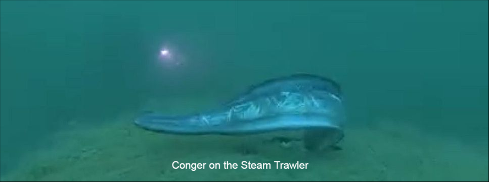
Dive details: Popular wreck dive. Split midships in 1987, 98ft by 31 ft steam trawler. Decks have now collapsed and lies broken on the seabed, but still plenty to see a good novice dive. The photo above is a conger on the Steam Trawler.
Ref: DS154
T.R. THOMPSON
Latitude: 50 40.20 N
Longitude: 00 05.60 E
Distance: 11.2nm bearing 137T from BRIGHTON 6.4nm bearing 168T from NEWHAVEN
Tonnage: 3538
Built: 1897
Sunk: 1918
Depth: 30m
Height: 14m
Dive details: An armed merchant steamship carrying iron ore. Sunk in March 1918 10 miles off Newhaven. Recognisable shape, collapsing internally, upright with a bad break half-way along, gun on aft deck. Lots of marine life.
Ref: DS 264
UNKNOWN 23 (Steam Drifter) otherwise known as THE VALE OF LEVEN
Latitude: 50 40.60 N
Longitude: 00 19.80 W
Distance: 11.5nm bearing 227T from BRIGHTON 9.3nm bearing 200T from SHOREHAM
Depth: 23m
Height: 7m
Dive details: Built in 1907 a 223 gross ton registered steam fishing trawler, in 1915 the military converted her to a minesweeper with a gun deck, sunk 10th July 1917 after colliding with SS Londonderry. She lies on her side in 24 metres South of Worthing in the Rampion Wind Farm. Lots of all kinds of life on this wreck. It is possible to enter via the bow if you are very careful. Reasonably intact, some stern superstructure. Engine room can be accessed with great care through the upturned and thinning hull but is not recommended. Be careful of the fishing nets.
References: DS 158
VASCO (SS)
Latitude: 50 39.50 N
Longitude: 00 01.90 E
Distance: 10.3nm bearing 149T from BRIGHTON 7.0nm bearing 188T from NEWHAVEN
Depth: 33m
Height: 5m
Dive details: A British armed merchantman ship, carrying general cargo, struck 2 mines in November 1916, lies off Beachy Head due South of Newhaven, locally known as SOUTH WRECK, sits atop a deep scour, 3 big holds and a deckhouse aft, bell recovered in 1990, identified by the china found at the site.
Ref: DS 228